- 0 Shopping Cart £ 0.00 -->


Medmerry Case Study
Coastal Realignment

Medmerry Case Study Coastal Realignment
Medmerry, West Sussex, on the south coast of England, is Europe’s largest coastal realignment scheme.

Medmerry Coastal Realignment
Why was the Medmerry coastal realignment scheme needed?
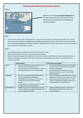
Medmerry had long faced problems with flooding from the sea, with regular breaches of the shingle bank, most recently in 2008, when over £5m of damage was caused. Several hundred thousand pounds were spent repairing and maintaining the shingle bank every year. Without annual maintenance, 348 properties in Selsey, a water treatment plant and the main road between Chichester and Selsey would be flooded, along with many holiday homes and rental cottages. The last time the sea breached the shingle bank in 2008, it caused damage totalling £5 million.
What is the Medmerry coastal realignment scheme?
Medmerry is the largest managed realignment of the open coast in Europe, and the first in the UK, on the stretch of the southeast coast most threatened by coastal flooding. The scheme has created an intertidal habitat, replacing vital areas lost in the Solent, allowing new defences to be built and protecting thousands more properties along the coastline.
The scheme is recognised locally, nationally and internationally as an exemplar scheme and is one of the most sustainable projects the Environment Agency has delivered.

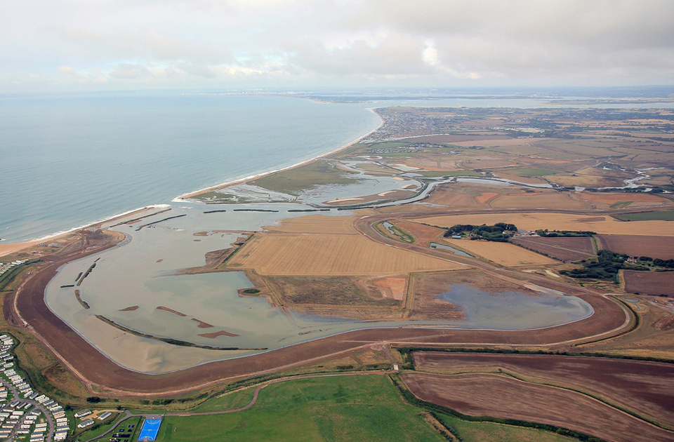
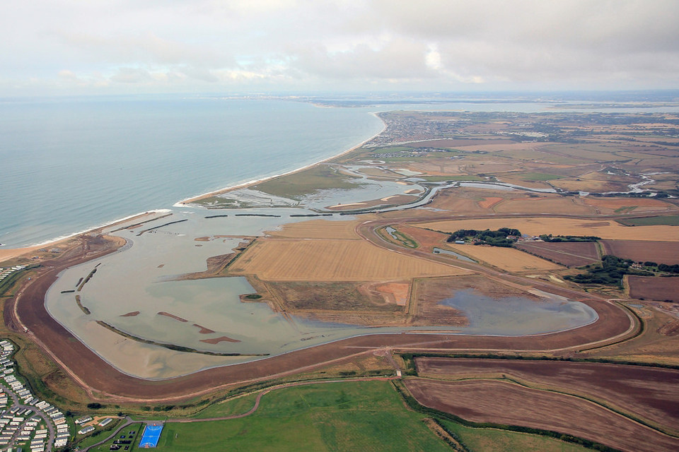
Aerial view of the Medmerry Coastal Realignment Scheme – Image: Environment Agency
Work began on the Medmerry Coastal Realignment Scheme in 2011 following a public consultation. It was completed in 2014. The project was achieved by:
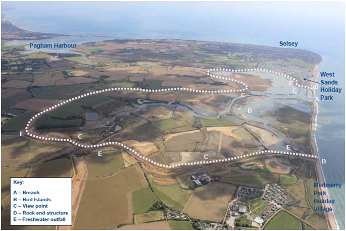
- Constructing a new 7km embankment using clay from within the area. The embankment created a new intertidal zone , protecting properties behind it from coastal flooding.
- A channel was built behind the embankment to collect draining water. This water is taken back into the intertidal zone via four outfall structures.
- Sixty thousand tonnes of rock from Norway was used to build up rock armour on the seaward edges of the embankment, linking to the remaining ridge.
- Once the rock amour and embankment were complete, a 110-metre breach was made in the shingle bank on the beach , allowing the sea to flood the land and creating the new intertidal zone.
What are the positive effects of the Medmerry Coastal Realignment Scheme?
What are the social benefits of the Medmerry Coastal Realignment Scheme?
- Selsey now has the best protection from coastal flooding, with only a 1 in 1000 chance of coastal flooding. 348 properties and sewage works are now protected to a standard of 1 in 100 years (previously just 1 in 1 year). The scheme avoided a possible breach during severe winter storms in 2013.
- The area now has ten kilometres of footpaths, seven kilometres of bike paths, and five kilometres of bridleways compared to the previous two small footpaths before the scheme was developed.
What are the economic benefits of the Medmerry Coastal Realignment Scheme?
- Caravan parks and Selsey’s main road route are now protected to a standard of 1 in 100 years (previously just 1 in 1 year).
- The local economy has received a boost from an increase in green tourism , and the caravan parks have been able to extend their season, generating income and jobs. Two new car parks and four viewing points give easy access.
- Vegetation on the salt marsh supports extensive cattle farming, producing expensive salt-marsh beef.
What are the environmental benefits of the Medmerry Coastal Realignment Scheme?
- The site contains 300 hectares of habitat of principal importance under the UK Biodiversity Action Plan, including mudflats, reed beds, saline lagoons and grassland. This includes 183 hectares of newly created intertidal habitat important to wildlife on an international level. It is crucial in compensating for losses due to development around The Solent, allowing the region to meet its European directive targets. Birds and other new wildlife appeared at the site long before completion.
- The area is now a huge nature reserve managed by the RSPB.
What issues and conflicts resulted from the Medmerry coastal realignment scheme?
What are the social issues of the Medmerry Coastal Realignment Scheme?
- Some residents feel that the Environmental Agency should have explored other options, such as an offshore reef or continued beach realignment, and not have given up on the land so easily.
- Some opponents from outside the area resented a significant sum of money being spent on a scheme in such a sparsely populated area.
What are the economic issues of the Medmerry Coastal Realignment Scheme?
- The project was expensive at £28 million compared to £0.2 million a year to maintain the shingle wall. Though with rising sea levels, this can be challenged quite easily.
- Good agricultural land was abandoned, leading to the loss of three farms growing winter wheat and oilseed rape.
What are the environmental issues of the Medmerry Coastal Realignment Scheme?
- Despite extensive planning , the habitats of existing species were disturbed.

Premium Resources
Please support internet geography.
If you've found the resources on this page useful please consider making a secure donation via PayPal to support the development of the site. The site is self-funded and your support is really appreciated.
Related Topics
Use the images below to explore related GeoTopics.
Topic Home
Next topic page, share this:.
- Click to share on Twitter (Opens in new window)
- Click to share on Facebook (Opens in new window)
- Click to share on Pinterest (Opens in new window)
- Click to email a link to a friend (Opens in new window)
- Click to share on WhatsApp (Opens in new window)
- Click to print (Opens in new window)
If you've found the resources on this site useful please consider making a secure donation via PayPal to support the development of the site. The site is self-funded and your support is really appreciated.

Search Internet Geography
Latest Blog Entries
Pin It on Pinterest
- Click to share
- Print Friendly
- Find Flashcards
- Make Flashcards
- Why It Works
- Tutors & resellers
- Content partnerships
- Teachers & professors
- Employee training
- Get Started
Brainscape's Knowledge Genome TM
Entrance exams, professional certifications.
- Foreign Languages
- Medical & Nursing
Humanities & Social Studies
Mathematics, health & fitness, business & finance, technology & engineering, food & beverage, random knowledge, see full index.
AQA GCSE Geography > 3.1.3.2 Coastal Landscapes in the UK - Medmerry Case Study - Coastal Management Strategies (Managed Retreat) > Flashcards
3.1.3.2 Coastal Landscapes in the UK - Medmerry Case Study - Coastal Management Strategies (Managed Retreat) Flashcards
Managed retreat:
form of soft engineering where low-lying and low value land is allowed to naturally flood so defences can be improved further inland
How is managed retreat a natural defence for the coastline?
- managed retreat allows floodwater to encroach on the land up to where the land is naturally higher
- this gives more space for wave energy to be absorbed
- as salt marsh and vegetation develops it provides natural defences against storms
- an earth bank is also built
- this is a natural looking feature that provides protecting in the even of a severe storm
How is managed retreat a sustainable option?
- in long-term, allowing managed retreat is more sustainable option than spending large sums of money trying to protect the coast with sea walls or groynes
- long-term option that recognises how the benefits of protecting low-lying land are outweighed by the costs
- salt marshes often develop from flooding associated with managed retreat
- this can become a natural form of coastal protection as mud is deposited and forms barriers against the waves
- it can also create new and valuable wildlife habitats
- as sea levels continue to rise, managed retreat seems likely to become an increasingly popular choice for managing the coastline
Why might managed retreat not be feasible for some parts of the coast?
- The value of the land e.g. high value agricultural land which is fertile and high yielding and contributes to food production is unlikely to be flooded - however, low-value grazing land could be
- Physical and human geographical features need to be considered
- Unique or high biodiversity or an important ecosystem would not be considered a feasible location to flood
- Topography – only low lying land would allow the sea to flood a large enough area
Aims of managed retreat:
- Improve coastal stability
- Protect areas of land further inland rather than those near to the coast
- Create natural defences to absorb and reduce the force of the waves e.g. salt marshes
- Shoreline Management Plans
- identify most sustainable approach to managing flood and coastal erosion risk in the short term (1-20yrs), medium term (50yrs) and long term (50-100yrs)
4 approaches to coastal management:
- no active intervention - sometimes known as ‘do nothing’, this is where there are no current plans to build defences
- hold the line - maintain current defences
- advance the line - increase coastal defences to extend the coastline out to sea
- managed retreat (realignment) - allow the coastline to achieve a new position further inland
What do SMP’s take into account?
take into account of the likely changes associated with climate change e.g. rising sea levels
What is coastal management being driven by?
- increasingly coastal management driven by costs and benefits, with only those areas of high-value lends protected by costly engineering schemes
- elsewhere, where he lands is relatively low value e.g. farmland or moorland, the ‘do nothing’ approach most likely to be adopted
- here it is more appropriate for people to adapt by relocating further inland
- this may involve moving mobile homes on a holiday park, relocating a coastal path or altering a golf course
- however, homes may be permanently lost in some locations
Where is Medmerry located?
stretch of coastline on the south coast of England near Chichester, West Sussex
How big is the realignment scheme in Medmerry?
Medmerry is largest managed coastal realignment scheme in Europe
What was the coast at Medmerry previously used for?
flat, low-lying coast use for farming and caravn parks
Why is the managed retreat scheme taking place at Medmerry?
- for many years, the land was protected by low sea wall, but now in need of repair - building a new sea wall to protect area against future sea level rise very expensive option so managed retreat scheme chosen
- given relatively low value of land, it was decided to allow Sea to breach the current sea defences and flood some of the farmland that was previously protected
How much does the Medmerry scheme cost?
costs £28mn
What will the Medmerry scheme do?
- create a large natural salt marsh to form a natural buffer to the sea
- help to protect the surrounding farmland and caravan parks from flooding
- establish a valuable wildlife habitat and encourage visitors to the area
What has been done so far at Medmerry?
- embankments have been constructed inland to give protection to farmland, roads and settlements
- alteration of the coastline is called coastal realignment
Advantages of Medmerry managed retreat scheme:
- It may help take the pressure off areas further along the coast and reduce their risk of flooding
- It is often cheaper in the long term to use managed realignment than to continue to maintain hard engineering defences
- Managed realignment is designed to conserve or enhance the natural environment
- It creates new intertidal habitats that compensate for those lost through coastal squeeze
Disadvantages of Medmerry managed retreat scheme:
- Relocation of people to new homes causes disruption and distress
- If the long-term plan for the realignment of 40 sq km of North Norfolk coast goes ahead, this will destroy 6 villages
- Short-term costs may be high. As relocation costs have to be paid
- The recent Medmerry realignment scheme, in West Sussex cost £28 million, when it only cost £0.2 million a year to realign the shingle beach
- Large areas of agricultural land are lost
- Habitats of coastal birds such as bitterns, cranes and marsh harriers would be affected, so bird numbers would initially decline
- It may take a long time for them to reach their previous numbers
AQA GCSE Geography (45 decks)
- 3.1.1.1 Natural Hazards
- 3.1.1.2 Tectonic Hazards
- 3.1.1.2 Tectonic Hazards: Effects and Responses to Tectonic Hazards (Earthquakes) - Nepal and Chile Case Study
- 3.1.1.2 Tectonic Hazards: Living with the Risks of Tectonic Hazards
- 3.1.1.3 Weather Hazards - Global Atmospheric Circulation
- 3.1.1.3 Weather hazards - Tropical Storms
- 3.1.1.3 Weather Hazards - Tropical Storm Case Study: Typhoon Haiyan
- 3.1.1.3 Weather Hazards - Weather Hazards in the UK
- 3.1.1.3 Weather Hazards - Extreme Weather Events in the UK: Somerset Levels 2014 Flood Case Study
- 3.1.1.4 Climate Change
- 3.1.2.1 Ecosystems
- 3.1.2.1 Ecosystems - Epping Forest Case Study
- 3.1.2.1 Ecosystems - Changing Ecosystems: UK Beaver Re-introduction Case Study
- 3.1.2.2 Tropical Rainforests
- 3.1.2.2 Tropical Rainforests - Deforestation in the Amazon Rainforest Case Study
- 3.1.2.2 Tropical Rainforests - Tropical Rainforest in Malaysia Case Study
- 3.1.2.4 Cold Environments - Polar and Tundra
- 3.1.2.4 Cold Environment - Svalbard Case Study
- 3.1.2.4 Cold Environment - Alaska Case Study
- 3.1.3.1 UK Physical Landscapes in the UK
- 3.1.3.2 Coastal Landscapes in the UK
- 3.1.3.2 Coastal Landscapes in the UK - Coastal Landforms at Swanage Case Study
- 3.1.3.2 Coastal Landscapes in the UK - Coastal Management Strategies
- 3.1.3.2 Coastal Landscapes in the UK - Medmerry Case Study - Coastal Management Strategies (Managed Retreat)
- 3.1.3.2 Coastal Landscapes in the UK - Keyhaven Salt Marsh, Southampshire Case Study
- 3.1.3.2 Coastal Landscapes in the UK - Lyme Regis Coastal Management Strategies Case Study
- 3.1.3.4 Glacial Landscapes in the UK
- 3.1.3.4 Glacial Landscapes in the UK - Lake District Cast Study
- 3.1.3.4 Glacial Landscapes in the UK - Cadair Idris Case Study
- 3.2.1 Section A: Urban Issues and Challenges - Megacities
- 3.2.1 Section A: Urban Issues and Challenges - Mumbai Case Study
- 3.2.1 Section A: Urban Issues and Challenges - Urbanisation
- 3.2.1 Section A: Urban Issues and Challenges - Bristol Case Study
- 3.2.1 Section A: Urban Issues and Challenges -The Distribution UK Cities
- 3.2.1 Section A: Urban Issues and Challenges - Freiburg Case Study on Sustainability
- 3.2.2 Section B: The Changing Economic World - Development
- 3.2.2 Section B: The Changing Economic World - Jamaica Tourism Reducing the Development Gap Case Study
- 3.2.2 Section B: The Changing Economic World - Nigeria NEE Case Study
- 3.2.2 Section B: The Changing Economic World - The Changing UK Economy
- 3.3.2 Section B: Fieldwork
- 3.3.2 Section B: Physical Fieldwork
- 3.3.2 Section B: Human Fieldwork
- Bristol Case Study (condensed)
- 3.2.3.3 Water: Lesotho Highland Water Project - Large Scale Water Transfer Scheme Case Study
- 3.2.3.3 Water: The Wakal River Basin - Local Scheme in LIC/NEE to Increase Sustainable Supplies of Water Case Study
- Corporate Training
- Teachers & Schools
- Android App
- Help Center
- Law Education
- All Subjects A-Z
- All Certified Classes
- Earn Money!
- International
- Education Jobs
- Schools directory
- Resources Education Jobs Schools directory News Search

Medmerry coastal realignment case study
Subject: Geography
Age range: 14-16
Resource type: Assessment and revision
Last updated
4 February 2020
- Share through email
- Share through twitter
- Share through linkedin
- Share through facebook
- Share through pinterest

A comprehensive one page case study of the Medmerry realignment scheme. Perfect for any specification, but written specifically for the AQA GCSE 9-1 course.
Tes paid licence How can I reuse this?
Get this resource as part of a bundle and save up to 75%
A bundle is a package of resources grouped together to teach a particular topic, or a series of lessons, in one place.
Case studies/Examples required for the AQA 9-1 GCSE specification
This is a bundle of 16 case studies/examples from the AQA 9-1 GCSE specification. This is a perfect set of resources to give to students to support them in preparation for this GCSE. Each case study/example is condensed to one A4 page, but contains the content that is required aligned with the specification. Each one of these is for sale at £2, but all can be bought together for £8! This has been produced by a team leader for AQA for this specification.
Your rating is required to reflect your happiness.
It's good to leave some feedback.
Something went wrong, please try again later.
This resource hasn't been reviewed yet
To ensure quality for our reviews, only customers who have purchased this resource can review it
Report this resource to let us know if it violates our terms and conditions. Our customer service team will review your report and will be in touch.
Not quite what you were looking for? Search by keyword to find the right resource:

COMMENTS
Medmerry Case Study Managed Realignment. Why was the Medmerry coastal realignment scheme needed? Medmerry had long faced problems with flooding from the sea, with regular breaches of the shingle bank, most recently in 2008, when over £5m of damage was caused.
GCSE AQA Geography CASE STUDY Learn with flashcards, games and more — for free. ... games and more — for free. hello quizlet. Study tools. Subject areas. Create. Log in. CASE STUDY: Coastal Realignment, Medmerry. Flashcards; Learn; Test; Match; Q-Chat; Get a hint. Began in 2011. Ended in 2014. Beginning and end dates of work ...
Medmerry Case study. 8 terms. Woody-Hall. Preview. GCSE Geography- Case study- The Jubilee River flood relief channel. 5 terms. will_turner41. Preview. Coastal System Overview. 73 terms. afernzno. ... AQA German A Level Vocabulary Unit1.2. Teacher 18 terms. Katharine_Stearn. Preview. History: India - Salt March & Civil Disobedience 1929-1932 ...
Study with Quizlet and memorise flashcards containing terms like where is medmerry?, why was management needed?, what strategy was used? and others. hello quizlet Study tools
Study 3.1.3.2 Coastal Landscapes in the UK - Medmerry Case Study - Coastal Management Strategies (Managed Retreat) flashcards from Janya And Chinnu Shailendra's class online, or in Brainscape's iPhone or Android app. Learn faster with spaced repetition. ... AQA GCSE Geography (45 decks) 3.1.1.1 Natural Hazards; 3.1.1.2 Tectonic Hazards;
This is a bundle of 16 case studies/examples from the AQA 9-1 GCSE specification. This is a perfect set of resources to give to students to support them in preparation for this GCSE. Each case study/example is condensed to one A4 page, but contains the content that is required aligned with the specification.
Question: For a named example, explain how the coast is being managed. (Medmerry - West Sussex) (Coastal Realignment Scheme - largest in Europe) *For the record - Gravity would not go down well if you revise this set with it.
GCSE GEOGRAPHY 8035/1 Paper 1 Living with the Physical Environment Monday 18 May 2020 Morning ... Use FIGURE 11 and a case study to explain your answer. [9 marks] ... realignment scheme at Medmerry, West Sussex. 0 3.2 Using FIGURE 13, state what has
Suitable for GCSE and A level. ... It uses Medmerry, West Sussex, as a case study. Medmerry is the largest managed realignment on the open coast in Europe. It is a multi-objective scheme, providing cost effective flood risk management for 348 properties as well as restoring 183 hectares of intertidal habitat. ... Geography, Teaching Geography ...
AQA GCSE Geography Complete Case Study and Example Booklet. Complete list of case studies and named examples for the course: Effects of and responses to a tectonic hazard in a HIC L'Aquila Effects of and responses to a tectonic hazard in a LIC Nepal Impacts of a Tropical Storm on people and the